Forces that shape the earth
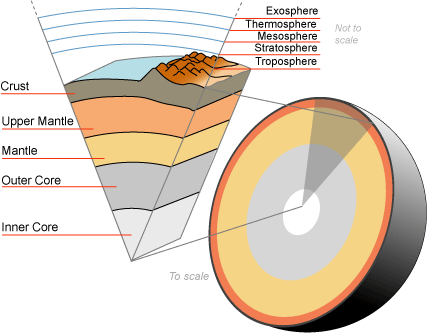
Figure 1 - Earth's layers
|
The Earth consists of four concentric layers: inner core, outer core, mantle and crust. The crust is made up of tectonic plates, which are in constant motion. Earthquakes and volcanoes are most likely to occur at plate boundaries.
The structure of the EarthThe Earth is made up of four distinct layers:
|
Plates Move
|
The movement of the Earth's tectonic plates is caused by convection currents in the mantle, which is the layer of hot, viscous rock that lies beneath the Earth's crust. These convection currents are driven by heat from the Earth's core and from the radioactive decay of elements in the mantle.
As hot material rises from the core and mantle, it moves the plates that lie above it, causing them to shift and move in different directions. This movement can result in various geological features, such as mountains, valleys, and oceanic trenches. The theory that explains this movement is called plate tectonics. According to this theory, the Earth's lithosphere, which consists of the crust and the uppermost part of the mantle, is divided into a number of plates that move and interact with each other. These plates can move apart from each other (divergent boundary), collide with each other (convergent boundary), or slide past each other (transform boundary). The movement of tectonic plates is a slow process that takes place over millions of years, and its effects can be seen in the geological features that are present on the Earth's surface. |
Video: Where the plates started and finished up to today.
Figure 3
|
Plate Boundaries
Plate boundaries are locations where two tectonic plates meet. There are three main types of plate boundaries: divergent, convergent, and transform boundaries.
|
MooMaths explains
|


|
The Rift Valley (Divergent)
|
San Andreas Fault (Transform)
|
Himalayas (Convergent)
|

Click the two buttons in Figure 4 above the video. They will take you to some websites that will explain the processes that shape the earth's crust. Also, I want you to watch the video in figure 5. Then answer the following questions in your workbook.
- Explain how plates move across the earth. Please be sure to provide geographic terms in your response and try refer to examples (locations where these processes are evident). Also refer to your source (the website) in your writing and be confident to draw diagrams showing your processes.
- What role does the Asthenosphere play in the movement of plates?
- Compare the three different kinds of plate boundaries. Explain the processes occurring and how they move. Consider how it impacts on the earth and provide an example of a location where these processes are taking place,
Earthquakes
|
Tectonic earthquakes are triggered when the crust becomes subjected to strain, and eventually moves. The theory of plate tectonics explains how the crust of the Earth is made of several plates, large areas of crust which float on the Mantle. Since these plates are free to slowly move, they can either drift towards each other, away from each other or slide past each other. Many of the earthquakes which we feel are located in the areas where plates collide or try to slide past each other.
The process which explains these earthquakes, known as Elastic Rebound Theory can be demonstrated with a green twig or branch. Holding both ends, the twig can be slowly bent. As it is bent, energy is built up within it. A point will be reached where the twig suddenly snaps. At this moment the energy within the twig has exceeded the Elastic Limit of the twig. As it snaps the energy is released, causing the twig to vibrate and to produce sound waves. |
Figure 3a) Where earthquakes occur
|
Perhaps the most famous example of plates sliding past each other is the San Andreas Fault in California. Here, two plates, the Pacific Plate and the North American Plate, are both moving in a roughly northwesterly direction, but one is moving faster than the other. The San Francisco area is subjected to hundreds of small earthquakes every year as the two plates grind against each other. Occasionally, as in 1989, a much larger movement occurs, triggering a far more violent 'quake'.
Major earthquakes are sometimes preceded by a period of changed activity. This might take the form of more frequent minor shocks as the rocks begin to move,called foreshocks , or a period of less frequent shocks as the two rock masses temporarily 'stick' and become locked together. Detailed surveys in San Francisco have shown that railway lines, fences and other longitudinal features very slowly become deformed as the pressure builds up in the rocks, then become noticeably offset when a movement occurs along the fault. Following the main shock, there may be further movements, called aftershocks, which occur as the rock masses 'settle down' in their new positions. Such aftershocks cause problems for rescue services, bringing down buildings already weakened by the main earthquake.
Major earthquakes are sometimes preceded by a period of changed activity. This might take the form of more frequent minor shocks as the rocks begin to move,called foreshocks , or a period of less frequent shocks as the two rock masses temporarily 'stick' and become locked together. Detailed surveys in San Francisco have shown that railway lines, fences and other longitudinal features very slowly become deformed as the pressure builds up in the rocks, then become noticeably offset when a movement occurs along the fault. Following the main shock, there may be further movements, called aftershocks, which occur as the rock masses 'settle down' in their new positions. Such aftershocks cause problems for rescue services, bringing down buildings already weakened by the main earthquake.
Case Study: 2023 Turkey Earthquake
|
On February 6, 2023, a devastating earthquake struck Turkey, causing widespread damage and loss of life. The earthquake, which had a magnitude of 7.1, was centered near the city of Adana, in the southern part of the country. The cause of the earthquake was the movement of tectonic plates along the Anatolian fault line, which runs through Turkey.
The impact of the earthquake was severe, with thousands of buildings damaged or destroyed, and many people injured or killed. The hardest-hit areas were the cities of Adana and Mersin, as well as the surrounding villages and towns. The earthquake also caused landslides and disrupted infrastructure, including roads and communication networks. In response to the earthquake, the Turkish government mobilized its emergency services and the military to assist in the rescue and recovery efforts. International aid organizations and neighboring countries also offered assistance, sending search and rescue teams, medical supplies, and other aid. The government set up temporary shelters and provided food and water to those affected by the earthquake. The management of the clean-up was a massive undertaking, as teams worked around the clock to clear debris and repair infrastructure. The government also prioritized the restoration of electricity and water supplies, as well as the repair of hospitals and other essential facilities. However, the scale of the damage was so extensive that it took several weeks for life to return to some semblance of normalcy in the affected areas.The earthquake highlighted the importance of disaster preparedness and the need for stronger building codes in earthquake-prone regions. Turkey is located in an area of high seismic activity, and earthquakes are a frequent occurrence in the country. Despite this, many buildings are not constructed to withstand earthquakes, which puts people at risk when earthquakes occur. In conclusion, the February 6, 2023, earthquake in Turkey was a tragic event that caused widespread damage and loss of life. The response to the earthquake was swift and comprehensive, with emergency services and aid organizations working together to assist those affected by the disaster. The management of the clean-up was a massive undertaking, and it will take time for the affected areas to fully recover. The earthquake serves as a reminder of the need for disaster preparedness and stronger building codes in earthquake-prone regions. |
Figure 4
Figure 5
|
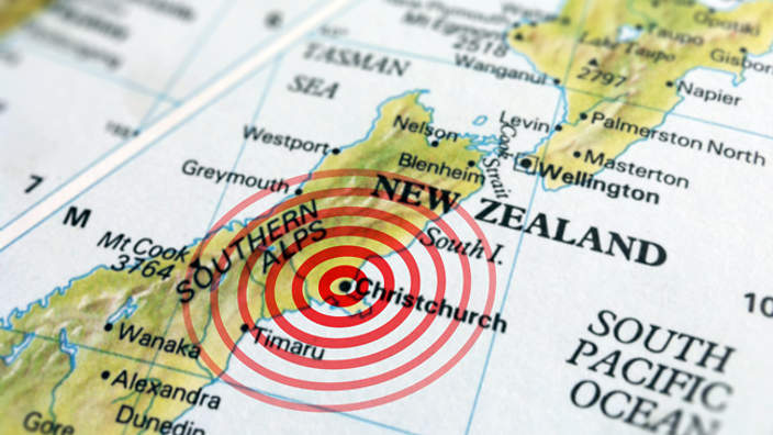
Case Study: The Christchurch Earthquake
|
On February 22, 2011, a 6.3 magnitude earthquake struck Christchurch, New Zealand, causing widespread devastation and loss of life. According to official reports, 185 people lost their lives, and over 1,500 people were injured, many of them severely. The earthquake's epicenter was only 10 kilometers southeast of the city center, and it occurred on a previously unknown fault line.
The earthquake caused extensive damage to the city's infrastructure and buildings. According to government estimates, over 10,000 homes were damaged or destroyed, and more than 1,000 commercial buildings suffered severe damage. The iconic Christchurch Cathedral suffered significant damage and had to be partially demolished. The earthquake also caused significant disruption to the city's utilities, with over 80% of the city experiencing power outages immediately after the quake. The water supply was also severely affected, with many residents having to rely on bottled water for days after the earthquake. The response to the earthquake was immediate and involved a massive emergency response effort. More than 1,500 personnel, including police, firefighters, and search and rescue teams, were deployed to the affected areas. The New Zealand Defense Force also played a significant role in the response effort, with over 2,500 personnel providing logistical support and assisting with the clean-up. The management of the clean-up was a massive undertaking, with over 1.5 million cubic meters of debris generated by the earthquake. The debris removal effort involved a large number of volunteers, as well as government agencies and private contractors. According to official estimates, the cost of the clean-up was over NZD 2 billion. The rebuilding effort in Christchurch has been ongoing since the earthquake, and it has been a significant challenge for the city. According to government estimates, the cost of rebuilding the city's infrastructure and buildings could exceed NZD 30 billion. As of 2021, over 10,000 homes have been rebuilt, but many areas of the city are still in need of repair. |
A lady grabbed hold of me to stop falling over ... It's not nice at all. We just got blown apart. Colombo Street, the main street, is just a mess ... There's lots of water everywhere, pouring out of the ground - its liquefaction - its an absolute mess." 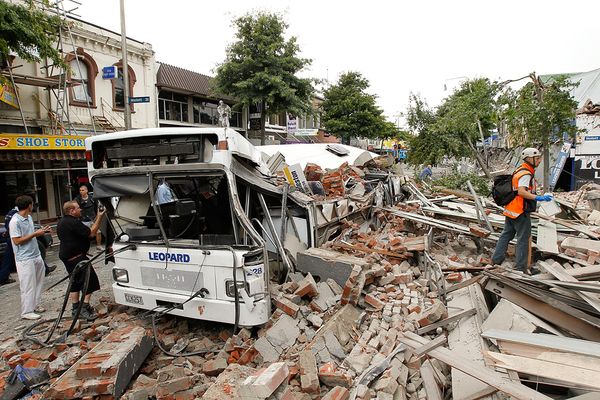
|

- Describe the geographic factors that led to the Christchurch Earthquake (cause). Then provide details on the environmental, economic an social impacts of the disaster.
Gradational Processes
|
Gradational processes, also known as Geomorphic processes, refer to the natural processes that shape and change the Earth's surface over time. These processes can be divided into two main categories: weathering and erosion.
Weathering is the process by which rocks and other materials are broken down into smaller pieces. There are two main types of weathering: physical weathering and chemical weathering. Physical weathering occurs when rocks are broken down by physical forces such as wind, chemicals and dust attached to water, and temperature changes. Chemical weathering occurs when rocks are broken down by chemical reactions, such as the reaction of rock with acid rain. Erosion is the process by which weathered material is transported and removed from one place to another. Erosion can be caused by a variety of factors, including wind, water, and gravity. For example, rivers and streams erode their banks and transport sediment downstream. Wind erosion can occur in arid regions where vegetation cover is low, resulting in the removal of topsoil and the exposure of underlying rock. Dust storms are the result of significant wind erosion. Deposition is the opposite of erosion and occurs when weathered material is dropped or settled in a new location. Deposition can occur through a variety of processes, including sedimentation in bodies of water, landslides, and volcanic eruptions. Gradational processes are responsible for the formation of many of the Earth's landforms, including mountains, valleys, canyons, and coastlines. Over long periods of time, the continuous action of these processes can lead to significant changes in the Earth's surface, shaping the landscape in diverse and fascinating ways. |
Figure 1: Causes and Impacts of weathering and erosion.
Figure 2: Different types of landforms caused by Geomorphic processes.
|
Human Interactions that lead to change due to Gradational Processes.
|
Human interactions with the lithosphere can have significant impacts on gradational processes, leading to changes in the Earth's surface and natural systems. There are several types of human interactions with the lithosphere that can affect gradational processes and their impacts, including:
|
Example of a mind map.
An example of the impact resource extraction can have on the Lithosphere.
|


|
|
|

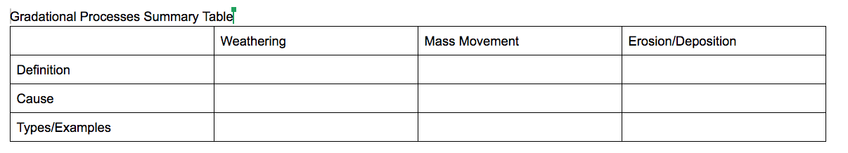
- Complete a summary table for gradational processes using the information on page 62 to 64 in your Textbook. Set it out as follows but allow yourself enough room to fill in the cells with appropriate room.
Copy down the different types of weathering using page 63 of your textbook.
Glossary
Soil
Land Degradation and Desertification
|
|
|
|
Complete questions 1-9 on page 75 in your textbook.
